It's a trip that Ben's talked about for a long time - heading up over the mountains from Bradley Lake and down into the Sheep Creek valley. Hike up, packraft out. Explore and adventure. We couldn't find anyone who had been overland in that area, or anyone to give us good recon info on the Sheep Creek. So in mid-July, Ben, Jeff, Ian and I set out to the head of the Bay to do some exploring for 5 days.
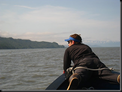
The head of the Bay is remarkably shallow at low tide. Ian was a good bow-lookout to help pole the boat around in a foot of water. We ended up leaving the boat on the east end of Bear Cove ... a good couple of miles from the "start point" of our trip.
 It took about 2 hours to hike over to the road, across the mudflats and little bays. The Bradley Road is a big, gravel, maintained road in the middle of nowhere. In the late 1980s a dam was built at the outlet of a natural lake, high up in the mountains. This road, which is 8.5 miles from the powerhouse at the Bay to the dam itself, is used by HEA workers to access the dam. It's also a great way to get above treeline!


The plant manager happened to arrive up there shortly after we did and gave us a fantastic impromptu tour of the place. It's fantastic infrastructure deep in the mountains; the power that is generated primarily goes up to the Railbelt. Check out this site from GVEA for a little more info on the Bradley Lake Hydroelectric Project.
We camped below the spillway that night, and the next day set out into the uncharted territory. It was SUMMER! No kidding. Those of you who have been spoiled, or tortured, with hot weather and unrelenting sun might not appreciate this. But it has not been above 60 degrees all that much here this summer. And rain. It's rained a lot. We're all a little grumpy, and more than a little Vitamin D-deprived. It took 2 more days of navigating to reach Sheep Creek. We got up to 4,200 ft of elevation, and ended up about 1.5 miles below the glacier that feeds the Sheep at 550 ft. We saw 5 black bears and expansive beautiful mountains, glaciers, rock and snow.
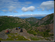


Once we had crested the highest elevation of our trip and started down, we stopped to have lunch and discuss our plan for descent. We had made it above the Sheep Creek Valley ... now just to get down.

Here's from our lunch spot. The lake is the glacier lake that is the head of the Sheep Creek, which you can just see the start of. The trick was to get down in an area where we wouldn't encounter un-traversable cliffs. We were fantastically lucky (with the help of some maps!) and made it down with little problem.

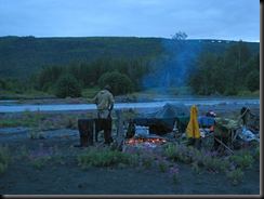
Here's sunset at our campsite down on the river. I didn't take too many pictures after this. Mostly because I was fairly terrified the better part of the following day...the river was a bit higher and faster and bigger than I was hoping for. Ian took lots of shots during the trip, including the river portion. He, Ben, and Jeff took good care of me - Ben was my personal hero and helped to portage my boat (which had a 50 pound backpack tied to it) many times across rocky bars to get around scary water/rocks. I cried, we portaged, we ran some water, I cried some more :) We all portaged for several hours around a long steep narrow canyon that couldn't really be scouted or trusted to be run. The boys would every now and then scurry over to the edge to peer over and admire the view. While I do now feel regret for not having joined them, I know that there was no other choice for me at that time. The trail was steep, and holding onto a tree with sweaty palms and a racing heart was about all I could manage! (aside from a little bit of crying) I'm sure Karen doesn't read this blog, but if you do - I thought several times of our spring break trip on the AT in Maine - heading up the icy mountains and similar feelings of terror striking me. I have been blessed with patient, kind, and wonderful people in my life in these trying times!
 Shortly after the canyon, the river mellowed out into Class II water with only some Class III bits, the Class IV was all behind us. Like flipping a switch I decided I was NOT going to sell my raft, my dry suit, my paddle, etc. and that I did indeed love packrafting!!! By the time we set up camp the river had slowed to Class I, we were wet and tired, and dinner was sounding very good.
The next day was a slooooow paddle/slog back to the boat, which was still ~8 or 9 miles away. It was a beautiful foggy/misty morning, clearing into a lovely afternoon.
After getting back to the boat, and stuffing our faces with ginger cookies that someone had stashed, I checked my messages and got one from my brother. He had made his way down to Homer and stayed that entire next week. We need to plan some explorations, or maybe a very tame cabin trip, for Labor Day weekend when he's hopefully back down here on his way to Maine.


